Climbing Gyebangsan Mountain: A Refreshing Hike in Gangwon-do
102-1 Nodong-ri, Yongpyeong-myeon, Pyeongchang-gun, Gangwon-do
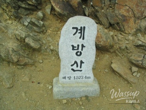
계방산


Gyebangsan Mountain(계방산), standing tall at 1,577 meters, is the fifth highest peak in South Korea. Spanning the border of Hongcheon and Pyeongchang in Gangwon-do, it is a key part of Odaesan National Park. The name itself suggests a mountain filled with the fragrance of cassia trees, offering a refreshing and aromatic experience for nature lovers.
Despite its impressive height, Gyebangsan is remarkably accessible thanks to the Unduryeong pass, which serves as the starting point. Starting at an elevation of 1,089 meters, hikers can reach the summit by navigating a 4.1km trail with manageable ascents, making it a popular choice for those looking to conquer a high-altitude peak without extreme physical strain.
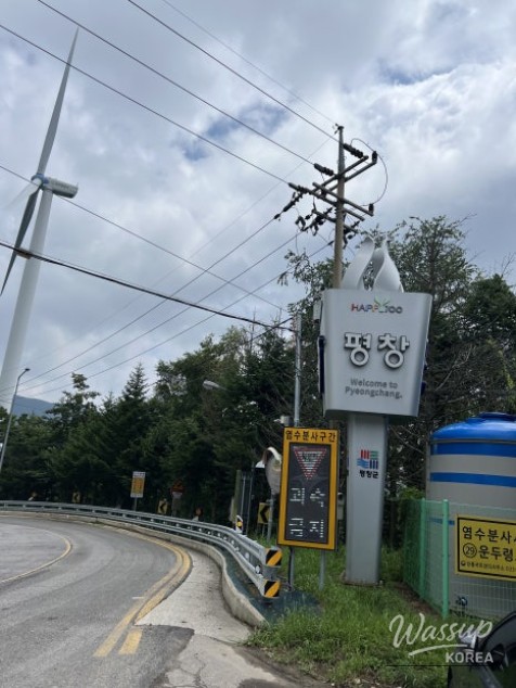
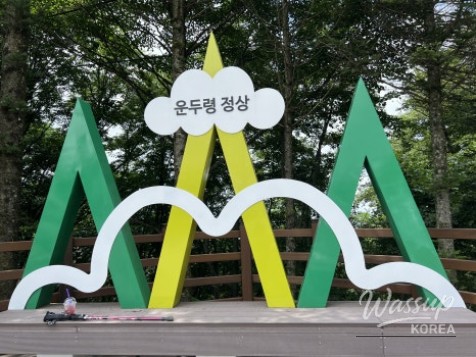
Starting Your Journey at Unduryeong Pass
Unduryeong is the highest point on any national highway in Korea, providing a significant head start for your hike. Since public transport is limited, driving is highly recommended. For those coming from Seoul, taking the Seoul-Yangyang Expressway to the Donghongcheon IC is the most efficient route. A useful tip for parking: the summit rest area lot is small and often filled with tour buses in the morning, so aiming for a visit after 11 AM can make finding a spot much easier.

Local Flavors at the Unduryeong Store
Before heading up, stop by the Unduryeong summit store. It’s a great place to pick up local delicacies like potato rice cakes and buckwheat pancakes for energy. They also sell unique Ganoderma lucidum (Reishi mushroom) soybean paste made by the local women's association—a perfect savory souvenir to bring home for 15,000 won.
The Trail: A 4.1km Path Through the Clouds
The hike begins with a set of deck stairs directly across from the parking area. The trail to the summit is roughly 4.1km and takes about one and a half to two hours to ascend. While the route doesn't feature many rocky outcrops, it offers a dense forest path rich in phytoncides. The total round-trip time, including rest stops, usually falls between 4 to 5 hours.

Picnics and Wildflowers at the Observation Deck
About 30 minutes before reaching the summit, you'll encounter an observation deck. This is an ideal spot to refuel with the snacks purchased earlier. The final stretch to the peak is particularly scenic, featuring colonies of wildflowers and unique dead trees that create a mystical high-altitude atmosphere.

Reaching the 1,577m Summit
The summit marker of Gyebangsan has been updated over the years, now standing as a prominent stone marker with Chinese characters. On a clear day, the 360-degree panorama is breathtaking, offering views of Seoraksan and Geumgangsan to the north, and Odaesan to the east. Even on cloudy days, the sense of accomplishment standing atop the country's fifth-highest peak is immense.

Post-Hike Healing: History and Wild Vegetable Bibimbap
On the way down toward Pyeongchang, history buffs can stop by the Lee Seung-bok Anti-Communist Youth Memorial Hall. For the perfect conclusion to your day, head to Buil Restaurant in Jinbu-myeon. Famous for its authentic wild vegetable bibimbap (13,000 won per person), the meal features dozens of mountain side dishes that embody the true taste of Gangwon-do. Adding a side of grilled Hwangtae (dried pollack) for 10,000 won is highly recommended.


Are you ready to experience the refreshing scent of cassia trees while standing atop one of Korea's highest peaks? If you're visiting Gyebangsan, don't forget to try the local soybean paste at Unduryeong. Would you prefer a quiet afternoon hike to enjoy the summit all to yourself, or an early morning start to see the sunrise?
No comments yet.